Home » Jason Warren
Category Archives: Jason Warren

Pre-plant Irrigation
Sumit Sharma, Irrigation Management Extension Specialist.
Jason Warren, Soil and Water Conservation Extension Specialist.
Pre plant-irrigation is a common practice in Western Oklahoma to recharge soil profile before growing season starts. Pre-plant irrigation is useful when the irrigation capacity is not enough to meet peak ET demand. It can also be important to germinate and provide for optimum emergence of the crop. As such, pre-plant irrigation is not useful when the soil profile is already wet, or soil profile is not deep enough to store moisture, or if planting dates are flexible and can wait until rains can recharge soil profile. Pre-plant irrigation becomes an important consideration if the previous crop had extensive rooting systems, which depleted moisture from deep in the profile. The crops in western Oklahoma especially in the Oklahoma Panhandle depend on stored water in the profile to meet ET demand during peak growth period, especially when well capacities are limited. Deep profiles and excellent water holding capacities of soil found in the region make the storage of a considerable amount of moisture possible. While pre-plant irrigation to recharge the whole profile (which can be 6 feet deep) may not be possible or advised, producers can still use certain tools to assess the stored water in the profile and make decisions on pre-plant irrigation.
A soil push probe (Figure 1) can provide a crude estimate of the moisture in a soil profile. For example, if an average person can push the probe to 2 feet, this means that the first 2 feet of the profile has moisture stored in it. The profile beyond 2 feet is considered too dry to push the probe through. This method does not provide the amount of water stored in the profile. For accurate measurements of soil moisture, soil samples could be collected, weighed, dried and weighed again to determine the water content in the soil. An alternative is to install moisture sensors, however this is usually not practical due to potential damage during planting, although some probes that can be permanently buried are becoming available. On average a clay loam soil in western Oklahoma can hold up to 2 inches of plant available water per foot. The approximate water holding capacity of your soil can be found on the websoilsurvey. Your county extension or NRCS personnel should be able to help you navigate this website if necessary. When the water holding capacity of your soil is known, the use of a push probe can provide a preliminary estimate of soil water content. Probing should be done at multiple locations in the field on both bare and covered (with crop residue) spots. The presence of crop residue reduces evaporation and increases infiltration so the first thing you will notice is that it is generally easier to push the probe into the surface where the ground is covered by residue. If the soil water content is near full the probe will be easy to push into the soil and it may even have mud on its tip when you pull it out. In this case you can estimate that the water content to the depth of penetration is near field capacity and that the current water content is equal to the water holding capacity. For example, if you can push the probe 2 ft into a soil with a water holding capacity of 2 inches/ft then we expect to have 4 inches of plant available water. In contrast if it takes some effort to push the rod 2 ft the estimated water content may be reduced.

When pre-irrigation is applied it can be useful to assess the increase in the depth to which the probe can be pushed into the soil after the irrigation event. For example, if 1 inch of irrigation is applied to the soil in the example above, we may expect that after this irrigation event we can push the rode 2.5 ft. However, in some case we may be able to push the rod 3 ft. The reason being that although we could not push the rod beyond 2 ft before the irrigation event, the soil below this depth was not completely dry. Therefore, the 1 inch of water was able to move to a depth of 3 ft. This is useful information, telling us that the soil below the depth we can push the rod contains some water and that each inch we apply may drain a foot into the profile. Generally, we expect the rooting depth of most crops to be able to extract water from at least 4 ft. Although it is certainly possible to extract water from below this depth, we generally don’t want to pre water our soils to full beyond 4 ft. When we fill the profile with pre water, we are increasing success of the following crop by providing the stored moisture that can offset deficits that may occur in the growing season. However, we are reducing our opportunity to capture and utilize spring rainfall. We must consider this when applying pre-irrigation, because if it is followed by rainfall in excess of ET our irrigation efficiency is greatly reduced by the drainage or runoff that can occur.
Saline and Sodic Seep Renovation A potential Positive Impact of Drought
This article is written by Dr. Jason Warren, OSU Soil and Water Conservation State Extension Specialist.
The drought has caused numerous negative impacts on Agriculture in Oklahoma. However its impact on our ability to renovate some types of Saline and/or Sodic soils has been a positive. Saline and sodic seeps are referred to by many names, including: salt spots, alkaline spots or slick spots. They are all similar in that they contain excessive amounts of salt or sodium that prevent plant growth. However there are various differences that influence how we renovate these sites.
These areas are classified by the amount and type of salt present. Saline soils are those that contain an EC greater than 4000 μmhos/cm and less than 15% Exchangeable sodium. A Saline/sodic soil contains an EC greater than 4000 μmhos/cm and greater than 15% exchangeable sodium. Lastly, the Sodic soils contain less than 4000 μmhos/cm and greater than 15% exchangeable sodium. Given these differences it is important to have soils from these barren areas tested before a renovation plan is developed. The soil tests will provide recommendations for renovation and more detail on these strategies can be found in factsheet PSS-2226.
Beyond the classifications briefly mentioned above there are different ways in which these saline and sodic soils form. Some of these soils are formed from parent material that contained excessive salt or sodium. Others are formed when ground water moves to the surface through evaporation and deposits salt as the water is lost to the atmosphere. The drought conditions we are current experiencing can impact our ability to renovate the latter.

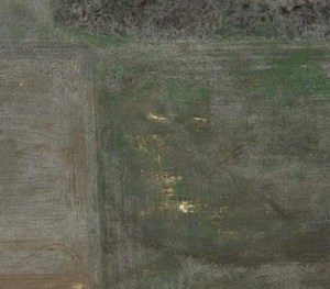
Figure 1: The upper picture was taken in Feb. 2011 and the bottom picture was taken in April 2013.
Hydraulic seeps, those formed from the movement of groundwater to the surface, are often found in low lying areas of the landscape where the groundwater is close enough to the soil surface that water can be conducted through capillary force to the soil surface. These forces are similar to those that allow use to suck water up through a straw but in the case of a saline seep evaporation from the soil surface provides the hydraulic gradient that pulls water from the water table. The drought has caused the water table in many areas to subside and become too deep for these force to pull water to the surface and deposit salts.
Figure 1 shows a saline/sodic soil in 2011 and again in 2013. This site had been treated with Gypsum as described factsheet PSS -2226 in 2007. However, because of a shallow water table that persisted until the onset of drought in 2011 the renovation effort was not successful because there was insufficient movement of water through the profile to leach the salts down out of the soil surface. These soils are in proximity to Stillwater Creek and Lake Carl Blackwell. The water table has declined which allows limited rainfall experienced at this site in 2012-13 to move the salts down out of the soil surface. This in turn has allowed crop establishment further improves water infiltration by protecting the soil from crusting.
The drop in most water tables across Oklahoma, particularly western Oklahoma where these salt spots are most common, provides for a unique opportunity to renovate hydraulic salt spots. Again the first course of action is to collect a soil sample to determine what types of salts are present. You can also make an effort to determine how the salt spot was formed. This information can be found on the soil survey at http://websoilsurvey.sc.egov.usda.gov/App/HomePage.htm. Your county extension educator or local NRCS can help to interpret this information.
We have observed that our success in renovating a hydraulic seep near Stillwater was greatly improved during this period of drought. However, given the fact that our sub soils are generally dry throughout Oklahoma, which improves our ability to leach salts, the drought should improve our ability to renovate those formed from parent material as well.
